BQ
Saba
The unspoiled queen of the Caribbean 's dive sites
The unspoiled queen of the Caribbean 's dive sites
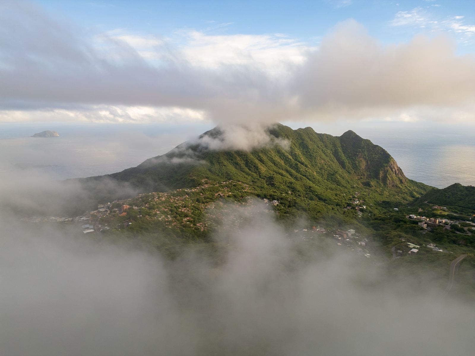
The highest point in the entire Kingdom of the Netherlands — a dormant volcano whose summit is wrapped in elfin cloud forest, with 1,064 stone steps from Windwardside leading through orchids, ferns, giant tree ferns and bromeliad gardens to views over the entire Leeward Island chain.
One of the top five dive sites in the world — vertical volcanic walls dropping to 300m+ are covered in massive barrel sponges, black corals, sea fans and patrolled by reef sharks, hammerheads, eagle rays and whale sharks seasonally. Visibility regularly exceeds 30m.
A perfectly preserved Dutch-Caribbean village of white cottages with red roofs, flower gardens and stone paths clinging to the volcanic hillside at 500m — more like a Dutch hill village transported to the tropics than any Caribbean cliché. The prettiest village in the Dutch Caribbean.
Saba’s oddly named capital (the name comes from the Dutch “botte” meaning bowl) sits in a volcanic crater at 245m elevation — a quiet, historic town with Dutch colonial architecture, the Sarah Doris Saba Museum and the weekly Saturday market that brings together the island’s 1,800 residents.
The cloud forest above 600m on Mount Scenery is one of the Caribbean’s most extraordinary ecosystems — permanently mist-wrapped, hung with mosses and orchids, with montane plant species found nowhere else in the Lesser Antilles. The transition from dry coastal scrub to cloud forest in 887m of altitude is astonishing.
A unique hand-drawn threadwork embroidery brought to Saba by a local woman who learned the technique from a Venezuelan nun in the 1870s — every daughter was taught the craft until it became a defining part of Saban identity. The lace workshop in Windwardside sells handmade pieces.
Saba (Wikipedia) →A dense, slightly sweet fried bread eaten for breakfast — Saban cooks add a distinctive blend of nutmeg, cinnamon, cloves and vanilla that gives every baked good on the island a warm spiced character entirely its own. The spice blend is called “Saban spice” by islanders.
Smoked herring cooked with butter, onion, tomato and scotch bonnet pepper, served alongside fungi (cornmeal porridge cooked like polenta) — the traditional Dutch Caribbean breakfast eaten throughout Saba, Statia and Sint Maarten.
Caught from the deep waters around Saba’s underwater mountain — mahi-mahi (dorado) is abundant and extraordinarily fresh, grilled simply with lime butter and served at the handful of restaurants in Windwardside and The Bottom. As fresh as fish gets anywhere in the Caribbean.
A local rum infused with fennel seeds, cloves, cinnamon and a dozen other spices — bottled and sold only on Saba, the homemade version is made by almost every family. The commercial version is sold at the airport and island shops. An aromatic, warming liqueur unlike any other Caribbean spirit.
Slow-cooked goat with Madras curry spice, potatoes and scotch bonnet pepper — the standard Sunday dish throughout the Dutch Caribbean. Saba’s version is mild by Caribbean standards, reflecting the island’s Dutch influence moderating the heat.
Chilled green coconuts from local trees, machete-opened at roadside stands — the standard refreshment after the 1,064-step climb of Mount Scenery. The coconuts grown at Saba’s lower elevations are particularly sweet.
Juancho E. Yrausquin Airport (SAB) has the world’s shortest commercial runway (400m). Only small aircraft land; Sint Maarten (SXM, 15 min) is the only hub. For trip planning, see the official Saba tourism portal.
💡 Winair (the Windward Islands Airways, based at Sint Maarten) operates the only scheduled service to Saba — the 15-minute flight in a 9-seat Britten-Norman Islander or Twin Otter is the main connection, with the approach to the 400m runway over the cliffs being one of the world’s most remarkable short landings.
💡 All visitors to Saba transit Sint Maarten. Allow at least 2 hours at SXM for the connection; Winair flights are weather-dependent and can be cancelled if conditions at Saba are unfavourable.
💡 Saba has one road (Queen’s Road, 9km from Fort Bay to St John’s) and a handful of taxis. There is no car hire; all transport is by taxi or on foot. The island is small enough that walking between The Bottom and Windwardside (30 min) is entirely practical.
💡 Saba has no cars for hire — the island is too small and the road too steep for self-driving to be necessary or practical. Taxis (US$8–25 per ride, fixed rates) connect all the main points; the hiking trails connect everything else.
Year-round is genuinely viable — Saba sits outside the main hurricane belt and has the most consistent diving conditions in the Dutch Caribbean. December to May is the driest season (24–28°C). The cloud forest is green year-round; the summit can be in cloud daily.
Saba uses the US dollar. It is affordable for the Dutch Caribbean — modest infrastructure keeps prices lower than Bonaire or Sint Maarten.
Saba spice (a traditional Saban liqueur made from rum infused with cinnamon, cloves, nutmeg, orange rind and anise &mdash)
Saba diving (the most affordable world-class diving in the Dutch Caribbean &mdash)
The Saba Bank expedition (a live-aboard or chartered dive boat trip to the submerged 2,200km²)
The Bottom for one day, Mount Scenery for one, diving for two days, Windwardside and lace for one, Sulphur Mine hike for one, Ladder Bay for one. Saba — an extinct volcano with no beaches — is the highest point in the Kingdom of the Netherlands, has the healthiest reefs in the Lesser Antilles and a hand-lace tradition brought by a Saban sailor from Venezuela in 1870.
The Bottom — the capital of Saba (a Dutch special municipality of just 13km² — an extinct volcanic cone rising steeply from the sea, the smallest special municipality of the Netherlands, population 2,000, the most extraordinary inhabited island in the Caribbean: a perfect volcanic cone with no beaches, only cliffs, an extinct crater at 870m and the most concentrated dive biodiversity in the Lesser Antilles) with the Harry L. Johnson Museum (Saban heritage in a traditional Dutch-Caribbean cottage) and the characteristic red-roofed white cottages of The Bottom.
💡 Saba has no beaches — the volcanic island rises steeply from the sea on all sides, with only one harbour (Fort Bay) and one airstrip (the shortest commercial runway in the world at 400m). Every building on the island is a traditional Dutch colonial style with white walls and red roofs — the entire island looks like a model village, set on a volcanic pinnacle surrounded by the Caribbean Sea. The road from the harbour to The Bottom was declared impossible to build by Dutch engineers; a Saban built it himself.
Mount Scenery (887m — the summit of the volcanic cone, the highest point in the entire Kingdom of the Netherlands including the European Netherlands, reached by the 1,064 stone steps of the Mountain Track from Windwardside village — 1–2 hours up through the cloud forest of tree ferns, heliconia and mountain mahogany, the summit in cloud most mornings but clear at dawn — and the Elfin Forest at the summit with gnarled, mossy trees in permanent mist).
💡 Mount Scenery (887m) is the highest point in the Kingdom of the Netherlands — higher than any point in the Netherlands proper (the highest point in the European Netherlands is the Vaalserberg at 322m) and higher than any point in the other Dutch Caribbean islands. The record is technically correct: the Kingdom of the Netherlands includes the European Netherlands, Aruba, Curaçao, Sint Maarten, Saba, Sint Eustatius and Bonaire; of all these, Saba’s volcano is the tallest.
Saba Marine Park (established 1987 — encircling the entire island from the high water mark to 60m depth, one of the first fully marine-protected Caribbean islands and one of the healthiest reef systems in the Lesser Antilles, with the Saba Bank — a submerged seamount 5km southwest of the island covering 2,200km², the largest atoll-type structure in the Dutch Caribbean and the most biodiverse marine area in the northeast Caribbean) accessible by boat in 15 minutes from Fort Bay.
💡 The Saba Bank (a submerged platform 5km southwest of Saba — 2,200km² of shallow reef at 20–40m depth, larger than Saba island itself by 170x — is the most important marine habitat in the Dutch Caribbean, with exceptional coral coverage and fish biomass, and is protected as a Particularly Sensitive Sea Area by the International Maritime Organisation. It is rarely dived due to the open-water exposure and the need for a live-aboard boat.
Windwardside (the main village of Saba — with the Saba Artisan Foundation (selling the distinctive Saban lace — Spanish work, a needle-lace technique brought to Saba in 1870 by a returning Saban sailor and made by Saban women ever since, the finest hand-lace in the Caribbean), the local restaurants and the starting point for the network of hiking trails through the cloud forest — the Crispeen Track, the Sulphur Mine Trail and the Sandy Cruz Trail).
💡 Saban lace (Spanish work — a needle-lace technique introduced to Saba in 1870 by Martha Zagers Hassell, who learned it in a Venezuelan convent, taught it to Saban women, and established it as the island’s primary cottage industry for 100 years) is sold at the Artisan Foundation in Windwardside for US$20–200+ per piece. The technique involves making patterns on a pillow using hundreds of pins to guide the thread — each piece takes 10–40 hours to produce.
The Sulphur Mine Trail (a 90-minute return hike from Windwardside to the site of a 19th-century sulphur mine in the volcanic cliffs above the sea — with the finest Atlantic views on the island, the smell of sulphur from the volcanic vents still active in the cliff face and the ruins of the 1875 mining operation — the most atmospheric hike on Saba) and the Flat Point beach area (the black volcanic boulders of the island’s only accessible shoreline).
💡 Saba’s sulphur mine (operated 1870–1875 by a Dutch company that extracted sulphur from volcanic fumaroles in the cliff face above the Atlantic — the operation was abandoned after a hurricane destroyed the landing stage used to load ships) represents the only serious attempt to commercially exploit Saba’s volcanic resources. The fumaroles are still active; sulphur crystals form on the rock surfaces above the mine entrance.
Fort Bay dive sites — the Tent Reef Wall (a sheer volcanic wall dropping from 10m to 40m+, covered in black coral, sea fans and sponges, with Caribbean reef sharks, nurse sharks and green turtles — the most dramatic wall dive accessible from Fort Bay), the Third Encounter (a seamount pinnacle rising from 40m to 15m, surrounded by circling sharks and schools of jacks) and the Diamond Rock (a basalt pinnacle emerging from the deep water, with pelagic fish, barracuda and manta ray encounters).
💡 Saba’s volcanic origin creates an underwater topography unlike any other Caribbean island — the island simply continues underwater, with vertical basalt walls dropping from the surface to 40m+, volcanic pinnacles rising from 40m to within 15m of the surface, and the seamount environment of the Saba Bank extending the reef ecosystem for kilometres. The lack of river runoff and the Marine Park protection give Saba consistently the best underwater visibility in the Lesser Antilles (30m+).
Ladder Bay (the original landing point of Saba before the harbour was built — accessible by descending 800 stone steps cut into the cliff face, the only way to land goods on Saba before 1972, with the ruins of a customs house at the bottom and the most dramatic coastal walk on the island — the steps are intact and the descent takes 30 minutes, the ascent 45–60 minutes) before flying from Saba (SAB) via Sint Maarten (SXM).
💡 The Queen’s Road (the paved road connecting Fort Bay harbour to The Bottom and Windwardside, completed 1958) was declared impossible to build by the Royal Dutch Institute of Engineers. Josephus Lambert Hassell (a Saban who taught himself engineering from a correspondence course) built the road anyway between 1943 and 1958, blasting through volcanic rock with hand tools and minimal equipment. The road remains the only overland route on the island.
Winair operates multiple daily flights from Princess Juliana International (SXM) to Juancho E. Yrausquin Airport (SAB) — one of the world’s shortest commercial runways (400m). The landing is spectacular; the flight reveals Saba’s extraordinary volcanic topography from the air.
Saba Marine Park is one of the world’s great dive destinations — but Saba has only a handful of dive operators. Book in advance, particularly for whale shark season (April-June) and Christmas/New Year period.
Saba’s coastline is entirely volcanic cliff; there are no sandy beaches. The island compensates with world-class diving, dramatic hiking and complete tranquility. The tiny settlement of Wells Bay has a rocky foreshore where locals swim.
As a Dutch special municipality, Saba uses the US dollar. There is one ATM on the island (in Windwardside); bring sufficient cash for local restaurants and the marine park dive permit fee.
The 1,064-step climb to the summit of Mount Scenery at 887m takes 1.5-2 hours. Start early (before 9am) to reach the cloud forest before the daily mist burns off and to avoid the midday heat.
A $3 day fee or $30 annual fee for the Saba Marine Park is collected at the port. This fee funds the park’s reef monitoring, conservation and maintenance — among the most transparently managed marine parks in the Caribbean.
Saba sits within the Dutch Caribbean triangle alongside Sint Eustatius and Sint Maarten, with Saint Kitts and Nevis, Anguilla, Antigua and Barbuda, Dominica and Montserrat forming the wider Leeward Islands neighbourhood.